

MANILA, Philippines — The Philippine National Police has officially placed all its regional offices, operational units, and frontline personnel on heightened alert as the country braces for the severe weather conditions brought by Typhoon Inday. The directive, issued on Thursday, July 9, 2026, ensures that the state’s primary law enforcement and rescue resources are fully prepared to mitigate the risks associated with the tracking cyclone.
According to a public statement released by the national police headquarters, the central command decided to elevate its status following continuous coordination with state meteorologists. The primary objective is to guarantee the immediate availability of emergency personnel, transportation assets, and communication systems in regions expected to bear the brunt of the storm. While the core of the typhoon remains at sea, its massive cloud band and peripheral winds are already impacting several coastal provinces, prompting local authorities to enact preemptive safety protocols.
PNP Prepositions Emergency Assets and Personnel Across Vulnerable Districts
In an official press briefing, Philippine National Police Community Affairs Division Chief Colonel Jonathan Abella detailed the extensive preparations currently underway. He highlighted that the organization’s specialized disaster preparedness and response protocols have been activated at all administrative levels. The state’s emergency response teams, which undergo rigorous training for deep-water rescues and structural extractions, are now on standby for immediate deployment.
Colonel Abella confirmed that key search and rescue equipment, including rubber boats, utility trucks, security patrol vehicles, and advanced satellite communication systems, have undergone thorough inspections. These resources are currently being strategically positioned in low-lying and landslide-prone municipalities, particularly across Northern Luzon. The proactive deployment aims to minimize response times during critical windows if flash floods or debris flows isolate rural communities. The police regional commands have also been instructed to collaborate closely with local government units and municipal disaster risk reduction management offices to streamline evacuation efforts.

Meteorological Overview of the Weather System
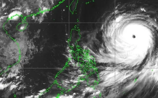
The Philippine Atmospheric, Geophysical, and Astronomical Services Administration reported that Typhoon Inday, which initially entered the Philippine Area of Responsibility as a category-five equivalent super typhoon, has slightly weakened due to an ongoing eyewall replacement cycle and structural interaction with dry atmospheric air. Despite this reduction in peak wind speeds, the system remains an exceptionally dangerous tropical cyclone, packed with maximum sustained winds of 175 kilometers per hour near the center and gusts reaching up to 215 kilometers per hour.
As of Thursday morning, the eye of Typhoon Inday was tracked approximately 925 kilometers east of Northern Luzon, progressing in a west-northwestward direction over the Philippine Sea at a steady pace of 20 kilometers per hour. State weather forecasters emphasize that the cyclone possesses a remarkably wide radius, with strong to typhoon-force winds extending outward up to 870 kilometers from its defined center. This expansive wind field explains why distant provinces are already experiencing intermittent heavy downpours and strong coastal gales well before the closest approach of the storm.
Wind Signal Number 1 Raised in Twelve Northern Provinces
To guide local governments and the public on potential wind hazards, the state weather bureau has placed twelve areas under Tropical Cyclone Wind Signal Number 1. due to Typhoon Inday These regions are projected to experience strong winds ranging between 39 and 61 kilometers per hour within the next 36 hours. Authorities note that while these winds pose minimal to minor threats to sturdy structures, they can cause significant damage to temporary housing, agriculture, and overhead power distribution lines. The areas currently under the wind warning include:
- Batanes
- Cagayan, including the vulnerable Babuyan Islands
- Isabela
- The northeastern portion of Quirino, specifically the municipality of Maddela
- Apayao
- The northern portion of Abra, covering Tineg, Lagayan, Danglas, San Juan, and nearby towns
- Kalinga
- The eastern portion of Mountain Province, encompassing Natonin and Paracelis
- The eastern portion of Ifugao, covering Aguinaldo and Alfonso Lista
- Ilocos Norte
- The northern portion of Aurora, specifically Dilasag and Casiguran
- The northern and central portions of Catanduanes
The Philippine National Police has sent additional personnel to these specific locations to monitor compliance with sea travel bans and assist in securing residential areas where forced evacuations may become necessary due to Typhoon Inday.
The Dangerous Interaction with the Southwest Monsoon
A major concern for disaster management officials is not just the direct wind impact of the storm, but its significant influence on the prevailing southwest monsoon, locally known as the Habagat. The massive circulation of Typhoon Inday is actively drawing moisture-laden winds from the southwest, creating a secondary weather hazard that threatens a much larger portion of the Philippine archipelago.
Meteorologists warn that the enhanced monsoon will bring moderate to intense rainfall over large portions of the Western Visayas, MIMAROPA, Central Luzon, and Metro Manila through the weekend. Mountainous areas in Occidental Mindoro, Antique, and Negros Occidental are particularly at risk for cumulative rainfall totals that could trigger severe flash flooding and rain-induced landslides. Because the soil in many of these provinces is already saturated from preceding weather disturbances, even brief periods of intense rain can lead to sudden slope failures. The police command has warned residents living near mountain slopes and river channels to heed early evacuation warnings issued by local executives.
Coastal Hazards and Strict Maritime Travel Restrictions
In conjunction with land-based preparations, due to Typhoon Inday the state has issued a comprehensive gale warning covering the northern and eastern seaboards of Luzon, as well as the eastern seaboard of the Visayas. Maritime authorities and the Philippine Coast Guard, working alongside maritime police units, are observing wave heights ranging from 4 to 6 meters in Extreme Northern Luzon, particularly around the coastal waters of Batanes and the Babuyan Islands.
Under these conditions, sea travel is deemed highly risky for all types of vessels, including large commercial ships and small outrigger fishing boats. All mariners have been strictly advised to remain in port, seek safe harbor, or delay transit plans until the severe wave conditions subside. Regional police officers stationed at municipal ports are actively enforcing these safety protocols to ensure that no fishing vessels venture out into open water, where the outer circulation of Typhoon Inday is generating unpredictable swell patterns.
Local Governance and Regional Police Directives
At the ground level, individual police regional offices have adjusted their operational readiness to match the specific threats facing their jurisdictions. In the Cagayan Valley region, which stands directly in the projected path of the typhoon’s outer rings, the regional director has ordered a full accounting of all search and rescue assets. Local police stations are helping municipal officials set up temporary evacuation centers, ensuring these facilities are equipped with basic sanitation, emergency lighting, and security personnel to prevent crime during temporary displacements.
Simultaneously, multiple local government units across Luzon have announced the suspension of classes Typhoon Inday in both public and private schools. These preventive suspensions aim to keep students off the streets, preventing situations where commuters could become stranded by sudden urban flooding or blocked roads. The Philippine National Police has deployed mobile patrol units along major highways to assist motorists, manage traffic bottlenecks caused by clearing operations, and monitor bridges that are prone to overflowing during cresting river levels.
Long-Term Forecast and Projected Exit Plan
The current track model provided by international and local meteorological agencies suggests that Typhoon Inday will maintain its west-northwestward or northwestward trajectory over the Philippine Sea over the next forty-eight hours. The system is expected to make its closest approach to Extreme Northern Luzon between Friday evening and Saturday morning, passing very near the island province of Batanes.
Fortunately, current simulations indicate that the core of the typhoon is unlikely to make a direct landfall over the main Philippine landmass. After passing close to Batanes, the storm is forecast to accelerate toward the southern islands of Japan and pass near the northern coast of Taiwan. State scientists expect the system to officially exit the Philippine Area of Responsibility by Saturday afternoon, July 11, 2026, before eventually heading toward the eastern coast of mainland China, where it is projected to make landfall on Sunday.
Despite the low probability of landfall, emergency managers stress that a non-landfalling typhoon of this magnitude can still cause severe damage through monsoon enhancement and coastal surges. The national police leadership has reiterated that its heightened alert status will remain in full effect until the weather system has completely cleared the territory and all displaced citizens have safely returned to their homes. The public is strongly urged to remain vigilant, ignore unverified social media reports, and follow the official advisories issued by state weather bureaus and local disaster management teams as the country manages the passage of Typhoon Inday.
Stay updated with the latest news at Metro Balita PH.